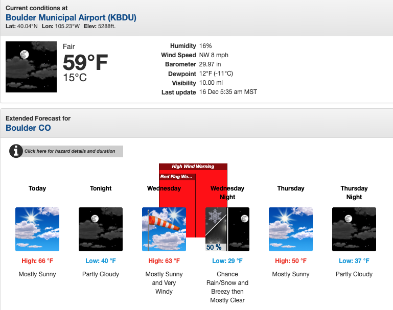
December 17 (Wednesday) – YRAIN Analysis (2025-12-16 00z forecast)
Potential Power Shutoff Announcement
On Monday, December 15, electric utility company Xcel Energy announced the possibility of a planned power shutoff on Wednesday, December 17, due to a forecast of extreme high winds.
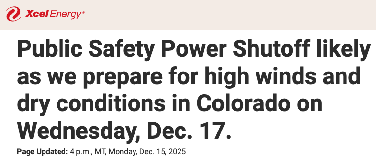
This decision follows criteria that have become common in Colorado and California in recent years.
When wind gusts of 70–90 mph are forecast together with dry and cold air, the risk of falling trees and contact with power lines increases significantly.
To reduce wildfire and infrastructure damage risk, utilities may implement a Public Safety Power Shutoff (PSPS)—cutting power before accidents occur.
NOAA NWS Forecast (Boulder, CO)
According to the NOAA National Weather Service (NWS) Boulder office, the forecast issued on December 15 included a High Wind Watch
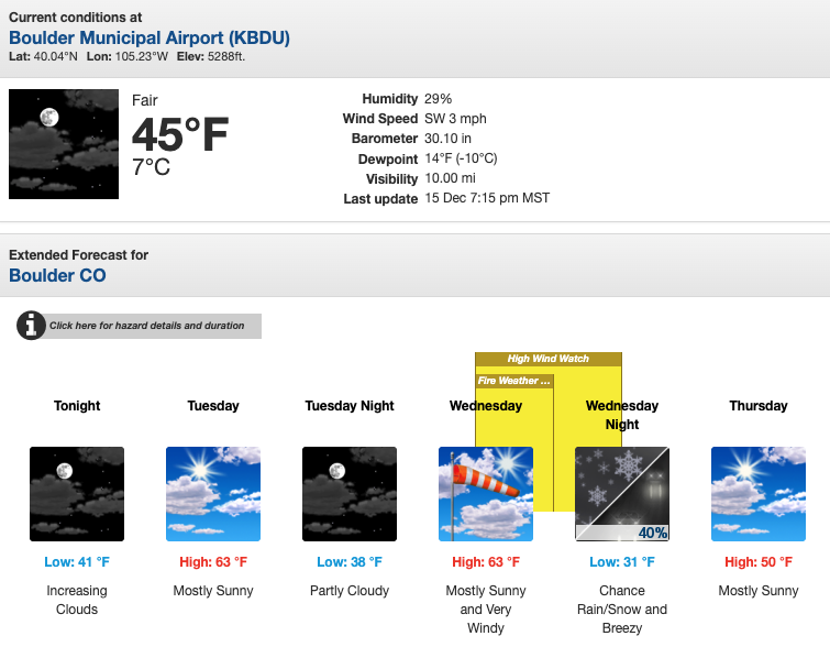
In the updated forecast on December 16, this was upgraded to a High Wind Warning.
Mechanism Behind the High Wind Event
Below, we explain the meteorological mechanism behind this high wind event using YRAIN Project visualization products.
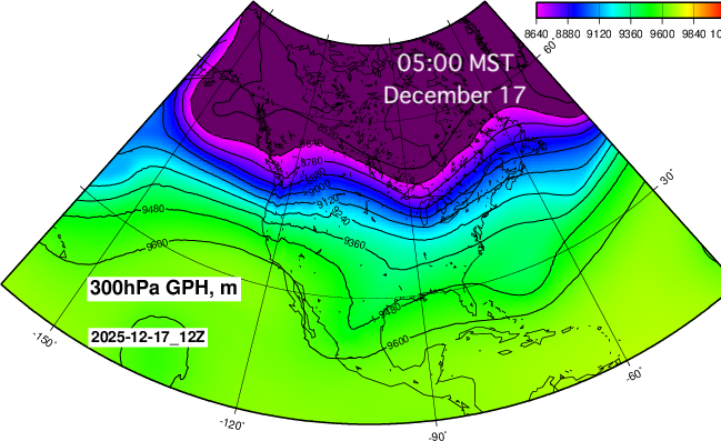
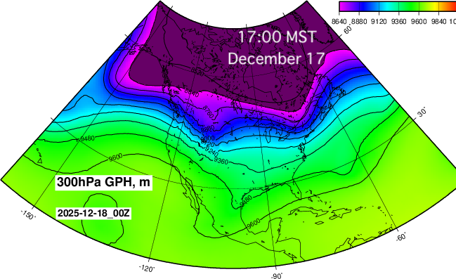
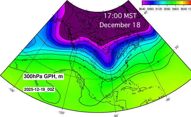
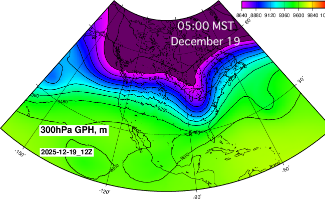
North America Upper-Level 300 hPa Geopotential Height, YRAIN.com
The figure shows geopotential height at 300 hPa, corresponding to an altitude of approximately 10 km.
Upper-level atmospheric patterns typically evolve ahead of surface conditions, making them useful for early diagnosis of strong wind events.
For conditions closer to the surface, 700 hPa (~3 km altitude) plots provide additional insight.
In the maps, purple and blue colors indicate colder air masses.
Southward Intrusion of Cold Air (Timeline)
December 17, 5:00 AM MST
December 17, 5:00 PM MST
December 18, 5:00 AM MST
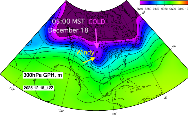
During this period, cold air is moving southward into Colorado from higher latitudes.
The tightly packed contour lines indicate a strong pressure gradient, also known as synoptic-scale forcing.
Because this gradient is oriented nearly perpendicular to the Rocky Mountains, very strong winds develop along the Colorado Front Range.
Why Surface Temperatures Do Not Drop Significantly
Despite the southward intrusion of cold air aloft, surface temperatures are not expected to drop dramatically.
This is due to downslope (foehn) warming, also known locally as a Chinook wind, as air descends from the Rocky Mountains toward the Front Range.
December 18, 5:00 PM MST
At this stage, the cold air mass begins to move eastward, away from Colorado.
December 19, 5:00 AM MST
Atmospheric Cross-Section Analysis
Next, we examine an atmospheric cross-section from the YRAIN Project.
Continental United States Atmospheric Cross-Section (GFS Forecast), YRAIN.com
Wind and Temperature Structure
The figure below shows an east–west atmospheric cross-section across the continental United States
(December 18, 5:00 AM MST).
- Arrows represent wind direction and strength
- Colors represent air temperature

Strong downslope winds descending from the Rocky Mountains are clearly visible.
Cold air (blue) is present aloft, but intense foehn warming occurs simultaneously along the Front Range.
As a result, surface temperatures do not drop to −10°C (blue), but instead remain around 0°C (yellow).
Water Vapor and Dry Conditions
The next plot shows water vapor distribution:
- Red: very dry air
- Blue: moist air
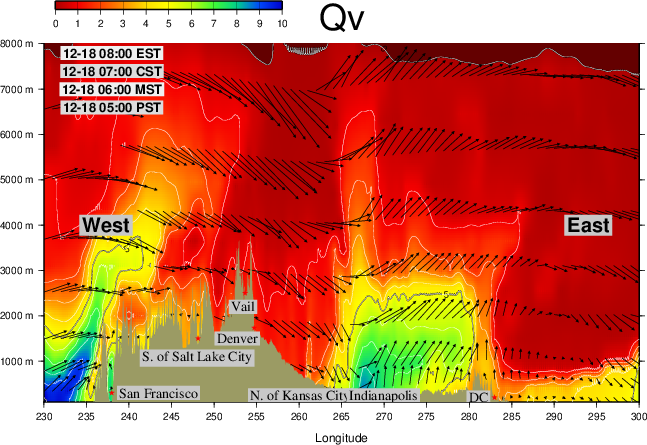
Colorado is covered by deep red shading, indicating extremely dry atmospheric conditions, which further increase risk during high wind events.
Polar Vortex Perspective
Finally, we examine the Polar Vortex plot from YRAIN.com (YRAIN Project).
Polar Vortex (US), YRAIN.com (YRAIN Project)
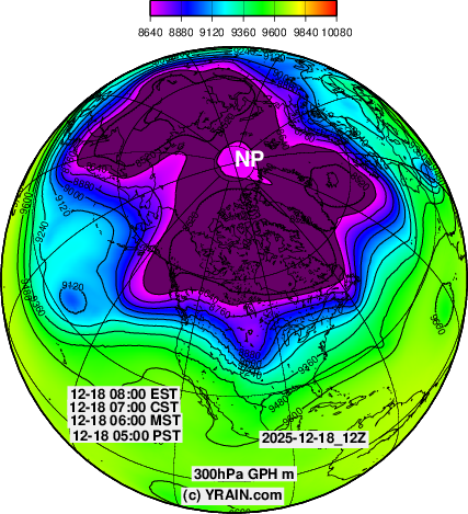
The plot shows 300 hPa geopotential height (~10 km altitude) at
December 18, 5:00 AM MST.
It clearly illustrates cold air associated with the polar vortex extending southward into Colorado.
Power Outage Preparedness (Amazon)
Amazon US
Portable power stations (Useful during power outages.)


Author / Project Credit
YRAIN Project
Weather & Environmental Data Visualization
NOAA GFS Forecast Visualization